Tide Tool is frozen code and has not been
maintained since 2007.
But I like the user quotes so am leaving this page up.
| A beta version of Tide
Tool is now available to incorporate the U.S./Canada Daylight
Savings Time change and recent NOAA tide data. |
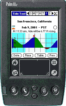
Tide Tool
is a freeware program to compute tides and currents
worldwide. It also provides some sun and moon data.
Requires:
- Palm
handheld computer. (All models. Some pre-1998
units, like the Pilot 1000 and Pilot 5000, and
PalmPilot Personals running the 1.0 OS, require
an upgrade;
see the FAQ.)
- Or the Handspring
Visor, or any other compatible device running
the PalmOS.
Features in Tide Tool 2.2:
(New 2.2 features in bold; other new version 2 features
in italics.
- Computes tides and currents from a worldwide
database of almost 7000
locations. Many locations in Great Britain have
been restored.
- Graphical or tabular display of
tides and currents.
- Tap the graph to get a prediction for a
specific time and date.
- Covers years 1998 to 2031
- User-selectable units of height and speed
- Displays times of sunrise/sunset, moonrise/moonset
and moon phases
- Displays in color (or grayscale)
on devices that support it, under Palm OS 3.0 or
later
- All regional databases can be loaded;
user can enable just those needed
- Program and data can be beamed.
- Program and/or data may be placed in expansion memory.
- The software and website are available in a French version.
- Tidal coefficients are displayed for French Atlantic
ports.
- A tide level guide, at a level selected by the user, may be displayed in the graph and table.
- Runs on Palm OS through version 5.3.
Other improvements from version 1:
- Major speed improvements (implemented by Jeff
Dairiki).
- Now using the XTide 2.6 database. Many new places have been added,
particularly in the U.S., Great Britain, Norway, Japan, Canada,
Alaska,
New
Zealand, Pacific Islands and Australia. German
data is improved. Some
database files have therefore gotten a lot
larger, even though they are better compressed.
- Secondary, or offset, locations (relative to
reference stations) are now incorporated in the
database. No, you
can't enter them, but you can contribute them
to the XTide
database and they will eventually get in.
How People Use Tide Tool:
Got an interesting use for Tide Tool? Please let
me know.
- From the Bay of Fundy: "We do
have large changes in tides. We also have the
Reversing Falls here in town. Visitors of course
want to know when to see the reversing. So it is
handy to have the tides on my Pilot."
- From Hawaii: "I'm a minister and
perform weddings on Maui. Tide Tool allows
planning of beach ceremony locations and
scheduling of sunset weddings. And it
looks major cool to whip out the Palm
Pilot."
- From British Columbia: I often go down to the ocean to pick up critters to feed to my
girlfriend's salt water fish, and it was constantly hit and miss. I
found your program and loaded it onto her Clie, and bam, wouldn't you know
it, in a few hours would be a super low tide, just a few blocks from my home
in Victoria. Incredible! On that trip I found a shield backed kelp crab (had never seen one before in my
life), a few wonderful looking eels, and some amazing shrimp that almost glowed in
the dark.
 From South
Africa: "I am the Station Commander of National Sea Rescue Institute, Station Six,
Port Elizabeth, South Africa. As a volunteer organisation we do not usually
have the luxury of having a tide table booklet on hand when an emergency
call comes in, and so, I find Tide Tool invaluable!" (Always
check against reliable tide tables when safety of life or property
is at stake. -WB) From South
Africa: "I am the Station Commander of National Sea Rescue Institute, Station Six,
Port Elizabeth, South Africa. As a volunteer organisation we do not usually
have the luxury of having a tide table booklet on hand when an emergency
call comes in, and so, I find Tide Tool invaluable!" (Always
check against reliable tide tables when safety of life or property
is at stake. -WB)- From San Francisco Bay: "I sail
a Nonsuch 33 on San Francisco Bay and your
program is easier and more convenient than the
local chart books. Tide Tool has become a
permanent addition to my PalmPilot." - Jeff
Hawkins, designer of the PalmPilot and Handspring
Visor
 From Alaska: "My husband and I run an air taxi service out of
Kodiak. We use Tide Tool to help us schedule our float plane flights and our bear viewing
tours, both of which are tide dependent.: From Alaska: "My husband and I run an air taxi service out of
Kodiak. We use Tide Tool to help us schedule our float plane flights and our bear viewing
tours, both of which are tide dependent.:- From Papua New Guinea: "
I was managing a project in Irian Jaya (Papua) and we ran 8 boats used to transport ± 75 people per day. We had up to 6 meter tides and everything had to be scheduled around tides."
- From Louisiana: I work at a Marine Research Center. We have
monitoring stations in place around the coast, and at least one of them is
in very shallow water. Since I use a Palm for communicating with several of the weather and water
instruments, I always have it with me. Tide Tool can save me from sitting on the little
instrument platform with my boat sitting in the mud, waiting for the tide
to come up.
- From Colorado: "My great-uncle, after whom I was named, just built a house on the inter-coastal waterway in Texas. I check this tool daily from Colorado and dream of buying the lot next to his after I retire"
- From Alaska: "I am a Tlingit Indian raised in Southeast Alaska. Tlingits have been around
Southeast Alaska for about 8000 years living off the sea. I use
Tide Tool to help me know the tides for fishing and
subsistence."
- From South Africa:
"I like to fish and having the tides helps. Also I'm a pagan who uses the moon in ceremonies, so having
the moon phases is nice, too."
- From New York: "I coach the
rowing crew at the U.S. Military Academy at West
Point and I thought the program would be really
convenient for when I'm planning the
training."
- From Georgia: "I live in Athens, Georgia, USA, which is totally landlocked. However, my
mother lives on Huspah Creek in Sheldon, SC. My little boy, age 2, misses
his grandmother (as do I). So once a day we sit in his room and bring up
Tide Tool so he can see how high the water is at Gran's house."
- From Brazil: You are helping people here in Brazil, to enjoy the beach on 4WD drive cars, safely.
- From Washington: "I am a
volunteer fireman. Our
department has a fire Rescue boat and it's
helpful to know what the tides are doing when we
go out on a rescue mission."
- From New York City: "We use it in our work in the Coast
Guard Auxiliary in NY Harbor, to see what's happening with tides and
currents for the boats we are helping out on our patrols. As a
watchstander at CG Station NY, it is a great help when I get asked the tide at various locations."
- From New Zealand:
"I am involved in land & marine Search
and Rescue. I have found Tide Tool to be an
excellent resource for tides, sun rise sun sets
etc."
- From California: "My
friends and I are an eclectic bunch of overgrown kids who are fond of single-malt Scotch and building
sand castles. I intend to calculate the estimated time of destruction of the completed
castle. We are always being asked if we will finish our constructions
before the tide takes it. (Of course, we always do. By definition -
when the tides comes in we're done.)"
- From Canada:
"I am a helicopter pilot on the west coast of Canada and I have to take
people out to the bush so they can "cruise" the timber (assess the
amount and value of a stand of trees). Quite often I use the ocean shoreline to
drop them off and pick them up. I work an area from Seattle
to Alaska and it is very hard to hard to keep track of tides without your
program."
- From California:
" I'm a Tugboat operator on San Francisco Bay. I use your program
virtually every day at work. I also use it for sailboat racing here on
the Bay."
- From Scotland: I do work with the Fife Ranger Service on the Eden Estuary Nature Reserve which
is subject to rapidly rising tides which can, and do leave visitors stranded. Your version 2.0 of the program is accurate to within 3
minutes at my location and has enabled us to be onsite at the correct times to guide people back to safety.
- From Oregon:
"I am a Paramedic on the Central Oregon Coast. We frequently have surfers, beachcombers, rock climbers and fishermen get into trouble and require rescuing.
I use Tide Tool to determine where the tide is at and how long we have to make the rescue."
- From Florida: "As the yakmaster for the
South Florida Bush Paddlers Association
I use Tide Tool to plan and execute trips. There's nothing worse than paddling for miles only to
find that the mangrove creek you were headed for is dry. Many a depressing
trip has been saved by a reroute spurred by Tide Tool."
- From the Marshall Islands: "I am the Bikini Atoll Dive Program
manager, which necessitates me needing to know the tides on a daily basis.
I also dive quite a bit in Majuro Atoll, the capital of the Marshalls."
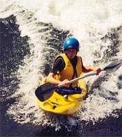 From Maine: "As the tide comes in through an inlet near Blue Hill Harbor it
creates a rapids as if in a river. Two hours before a
certain height of high tide, the inrushing current forms a
standing wave. It is sometimes over 6 ft tall and stands in one place, so you can surf a kayak
or a surfboard indefinitely because the wave isn't going anywhere."
(See photo) From Maine: "As the tide comes in through an inlet near Blue Hill Harbor it
creates a rapids as if in a river. Two hours before a
certain height of high tide, the inrushing current forms a
standing wave. It is sometimes over 6 ft tall and stands in one place, so you can surf a kayak
or a surfboard indefinitely because the wave isn't going anywhere."
(See photo)- From France: "I find Tide Tool
very useful as a WW II tour guide in Normandy dealing with the liberation."
- From San Francisco: "I
am with a group of swimmers called the Sunrisers.
We swim in the San Francisco Bay every day of the
year. There are massive currents here coming
through the Golden Gate - up to 6 or 7 knots
going one way or the other. And yes, the water is
cold - 52 degrees this morning. You can imagine
that the Tide Tool is essential for us. Many of
us use it every day."
- From Brazil: "I take part of a group that makes off-road rides along our desert beaches
and the behaviour of the tides is essential to guarantee the safety of the ride."
- From Florida: We used it this year during the opening days of lobster season to dive the Florida Keys Bridges at slack
tide. I owe you a lobster dinner!
- From Australia: "I used it recently
to plan a drilling investigation in Western
Australia. A work schedule was planned to drill
boreholes in the tidal zone. Get in and get
out - without getting wet! I also used it
to establish the approximate tidal range in the
Philippines for a prospective project. My brother
in Wales uses Tide Tool to time trips to the
beach so his wife can ride her horse on the
sands."
- From Long Island Sound: "My hobby is metal detecting and I hit the beach a lot. I use it to find the real low tides by
calculating the moon phase with the tide to get the lowest point possible. This way
I find the good stuff."
 From
France: "My boat is used for scuba
diving and fishing in Locquirec, Britanny. This
little harbour has a tidal range of 9.90 m (32')
and we have to deal with that: no water, only
sand at low tide!" From
France: "My boat is used for scuba
diving and fishing in Locquirec, Britanny. This
little harbour has a tidal range of 9.90 m (32')
and we have to deal with that: no water, only
sand at low tide!"- From New York: "I have
already used it to determine sunrise at Montauk
Point Lighthouse for a photo session by my wife,
and the tide a couple of miles along the beach to
photograph gray seals."
- From Florida:
"Now when I leave the dock and have forgotten to check the tide on my
PC in my rush to go, I don't have an anxiety attack."
(From a psychologist)
- From Victoria, British
Columbia: "As flatwater rowers on the Gorge/Selkirk Waterway, we rely a great deal
on Tide Tool to help us anticipate the condition at the reversing narrows
at Gorge-Tillicum Bridge. Only twenty feet wide at low tide and currents in
excess of 11 knots at max, it's nice to know when not to go through. If
you're just guessing, you might row up, but 20 minutes later you'll be stuck
till next slack water (or swimming beside your upside-down shell!)."
- From California:
"I am a Supervisory National Park Ranger on Alcatraz
Island. Tide (and wind) affects our ability to get visitors
on and off the island. (Good thing the inmates didn't have Palms and your software!)"
From Connecticut: "We are sea (ship) pilots in the Long Island Sound,
Narragansett Bay, Cape Cod Canal, and points east. We probably have a hundred (or more)
tide and current stations that we have to deal with. Until your program
came along we had to lug a book of tide tables and currents around."
- From Australia:
"I have found your program wonderfully helpful in my
shipwreck conservation management program during field work and just want to
thank you from the bottom of the ocean and the bottom of my heart."
- From California: "I am a wildlife biologist and am very dependent on the tides here for my job. Now I have them in the palm of my hand. The days of the soggy tide book are over."
- From Wales: "I make regular
wildfowl counts on estuaries and need to plan ahead when I can do them - the dates of the
counts being dictated by the tides."
- From Washington:
"A friend of mine is Muslim. He asked me if I knew what time local sunset was, as he wished to end his fast for the
day."
- From Maryland: "I live on Maryland's Eastern Shore. Last month I booked a
charter on a Skipjack for a dozen friends to come to my dock. The Capt.
said the charts showed there was not enough water. I whipped out
my Palm and said there will be on September 12th at 7 p.m. (this was mid
August). Astonished the Capt. said OK!? But you still have to pay me if I
can't get in. The tide was 2 feet above normal - just as it said!"
- From New Zealand: "I use it in the film &
TV industry for scheduling shooting days, it provides all the information we need to plan around
sunrise/sunset and the tides."
- From Maine: "That is sooo awesome. I am a
guide for L. L. Bean. Several of us use your application."
- From Washington: I've been using it to plan Puget Sound dives
for our university scuba diving club. I always have it with me (unlike paper tables) and
I can look up the historic data for dives from a couple years ago
when planning future dives.
- From New Jersey: "Burlington
City Fire Department & Endeavor Emergency Squad is responsible
for river dive rescue and other emergencies so knowing the tidal
change is very inportant. We also use it for high tide stats
to know when we can use the river for a water source by a Fire
Engine."
- From New Zealand: "I live on the south shore of the Waitemata
Harbour (Auckland) and work on the north shore. Tide Tool lets me know when
I can kayak to work (within 2 hrs of high tide) and when I'll end up walking
most of the way through silt and mud!"
- From Connecticut: We observe 'colors', the daily ritual of flag lowering, and like to be on time. The sun sets below our visible horizon and
Tide Tool has been invaluable to settle all arguments. Once or
twice a month we look for moonrise, jump in a boat and catch the moon rising out of Long Island
Sound.
- From Newfoundland: "As Commodore of a local
yacht club we rely on tidal information to permit the launching, lift-out and servicing of many of our vessels. Now it's at our fingertips, any date any time."
- From Morro Bay, California:
"I walk my dogs at low tide. One of my dogs is a whippet and he needs a lot of
space to run. I collect beach glass during the walks and the lower the
tide the better."
- From Hawaii: "I am a geologist, and much of our work is conducted in near shore
areas. I find the Tide Tool is very helpful in predicting depths to shallow
groundwater in tidally influenced areas when conducting subsurface
investigations."
- From New Jersey:
"I plan my family vacation to the Jersey
Shore using this tool. It's best during a week
when low tide is in the afternoon. At low tide,
the beach is wider and waves calmer, perfect for
my two toddlers to play on the beach."
- From South Carolina:
"Here in Charleston, SC, the streets downtown often flood during high tide.
Tide Tool really helps me avoid traffic jams, or even worse, getting stuck!"
- From Canada: "As the Rear
Commodore for the Vancouver Branch of the
Canadian Forces Sailing Association I have
staffed the project to put your software on Palms
into our over 25 foot vessels."
- From Australia: I am a scuba instructor in Sydney and some of our dive sites are a
little treacherous on certain tides and changes. Also some sites can only be
dived at certain tides. It gives me a great indication of both the tide and the height of the tide. I
know what sites I can use and what entry and exits I can use from the
tide levels.
- From California: "I'm the Navigator and Operations
Officer on board a nuclear-powered fast-attack submarine home ported in San
Diego. I have been using your Tide Tool from San Diego, CA to
Esquimalt, B.C., to Ketchikan, Alaska, to Pearl Harbor, Hawaii, to Yokosuka, Sasebo,
and Okinawa, Japan, to Chin Hae, South Korea, to Guam and
back." (Umm - great, but always check against
reliable tide tables when safety of life or a billion dollar piece
of the taxpayers' property is at stake. - WB)
- From Long Island, New
York: "We are water-skiers and we
have a tournament-type slalom course set-up in a
secret location. We have a small window at high
tide when we can get our boats in there so we
must follow the tides very closely."
- From New Zealand: "I
work with penguins around the southern coasts of
New Zealand. Many colonies are only accessible at
low tide."
- From California:
"I am a California Fish and Game
Warden. I was recently given your email by the
U.S. Coast Guard to obtain a tidal cycle
application to put into my Palm Pilot."
- From Georgia: "I am a Real Estate on Saint Simons Island, Georgia and I use Tide Tool
to determine when I will take pictures of a property."
- From Iceland: "I
am a dentist in the U.S. Navy, stationed in
Keflavík, Iceland. I am an avid surfer and
fisherman and rely on tidal data to plan my
recreational activities."
- From California: "I use it for
kitesurfing in the San Francisco Bay. Best kitesurfing during
ebb tide. I also hang glide on the cliffs. If the winds die while we're
flying, Tide Tool lets us know if there will be enough beach for a safe landing."
- From South Carolina: I am the General Manager of a Planned
Community on Hilton Head Island and will use the tide information to help
set our work schedules. We are in the process of renovating several of our
outfall structures that lead into tidal creeks. We are also installing revetment along a bluff area.
This will allow us to plan our work around low tide.
- From New England: "I'm
a U.S. Navy officer. Moving submarines into and
out of drydock, we need to know which days will
produce enough tide, and what time, so that
docking evolutions can be scheduled, planned, and
executed. The rapid currents often require
certain craft movements be done at slack water.
Even when we're not moving submarines around,
there are few things as bothersome as walking out
to inspect the pier and finding out that it's
high tide when I get there." P.S.: When they
dock a $1 billion nuclear submarine in shallow
waters, they verify against the official NOAA
tide tables.
- From Norway: "Being in a long fjord; going from my harbour to the coastline takes me
four hours against the tide and three hours if I go with the tide. Tide
Tool helps me saving both time and fuel."
- From California: As a professional photographer I'm doing portrait sessions at the beach every week and
depend on Tide Tool to plan my sessions.
- From British Columbia: "I paddle Discovery Passage in my kayak. The currents run as hig as 15
knots with back eddies, whirl pools, and overfalls. I need to know the slack periods and the direction. If I'm wrong I won't get home that day. Not unusual to paddle 20 miles after work and before dark using the currents."
- From Mississippi:
"We use Tide Tool in planning hydrographic surveys in support of the US Navy. While we don't rely on your program as a
data source for our collection of hydrographic data, we do use it to plan
for tide ranges and the impact they will have on our operations worldwide."
- From Washington: "I was working in the Duwamish Waterway with our
E.P.A. dive team taking samples and placing cages with fish for a contaminant
study. I've loaded in Alaska, the West Coast of Canada, the US, Mexico and Pacific Islands (our Region supports
work in American Samoa and other islands)."
- From Florida: "We usually hunt
fossilized sharks teeth which can only be done
around low tide - now I can beat the neighbors
for the good ones!"
- From Maine:
"Until recently, our office was located on
the bank of the Kennebec River in Hallowell,
Maine. The river is tidal, and frequently floods
the parking lot at high tide, so Tide Tool helped
me know when I needed to go down and move my
car!"
- From Thailand: "As a SCUBA
instructor, I find it very handy to arrange my
trips for my students' open water
examinations."
- From New York: "I use it for planning paddle trips for a bird club, a paddling group, and for my agency, the NYS Dept. of Environmental Conservation."
- From Brittany, France:
"Since I'm a little boy, reading Tide Agenda
in the newspaper is part of my life. Now, I can
prepare fishing game (or picnics with family) for
week-end, long time before, according to TideTool
predictions. I beamed the software to a friend's
Palm. In July, he went from Port-Navalo (Southern
Britanny) to Jersey and Guernsey (Channel
Islands). He just said 'This Tide Tool makes me
crazy; You can't imagine how much time I spared
using it, instead of usual calculation'. But yes,
I just do imagine!"
- From California: "I use it for
planning coastal surveillance as a Navy
Reservist."
- From Sweden: "In Europe at the
North Sea shores one can walk out for kilometers
(miles, whatever) as far as you can see at low
tide. One needs to know when the water is
supposed to come back, as you have absolutely no
chance to survive (as numerous idiots prove every
year) if you are out when the tide comes
in."
- From the southeast U.S.: "I am
an avid fly fisherman and here in the southeast
our fishing success is greatly influenced by
tidal conditions. My buddies that are using your
program love it. It helps them determine
when to cut out of work for a few hours, when
things are right!!!"
- From England: "In Britain,
a lot of rock climbing goes on on sea cliffs.
Well, it is an island. Knowing the tide times
becomes very important. I.e., are you going to be
able to climb on a
particular cliff at all? or will you go inland
instead?"
- From California: As a seabird surveyor for the Federal Government, I find your application
indispensable when we need to use the boat for our surveys.
As a recreational birdwatcher, I use it frequently to see when it is best to head out to my favorite high-tide roost.
- From Germany: "Your Tide Tool works
great and is an absolute must in a city like
Hamburg." (see postcard, right).
 Andreas
further advises: "The scene is real and
happens every once in a while a 10 minute walk
away from where I live. The guys from the fire
department usually only watch it happening and
only start retrieving cars which start to drift
around. A big crowd is cheering for the owners
who finally drop their trousers and try to get to
their cars ..." Andreas
further advises: "The scene is real and
happens every once in a while a 10 minute walk
away from where I live. The guys from the fire
department usually only watch it happening and
only start retrieving cars which start to drift
around. A big crowd is cheering for the owners
who finally drop their trousers and try to get to
their cars ..."
- From Arizona: "I teach an
introductory oceanography class, and we take
field trips to the Gulf [of Mexico] twice a year.
For this, we have to pick times of the highest
tidal range."
- From Columbia:
"We are having a great time using your tool
to help knowing when we can navigate through the
coral channels on the island of the Colombian
Atlantic Coast."
- From Florida: "Hey Brother, you
have a program that helps me catch the waves by
letting me know when the tide is right for my
local break. Thanks from a Florida
Surfer."
- From New Zealand: "G'day Walt -
I live 10 minutes away from the world's most
beautiful beach if it's low tide!
Otherwise, I live 10 minutes away from the
world's rockiest beach."
- From Puget Sound: "I'm a sea
kayaker, and have a PilotPro surgically implanted
(according to my wife) -- one of the guys I work
with has a Personal Pilot, and is a scuba
enthusiast."
- From California: "Tide Tool has
already been really useful for planning beach and
tidepool outings, making future camping
reservations, etc."
Other Tide
Software:
- Tides
lets you download, store and display tide tables
on your Palm Pilot. If you want to conserve
RAM, or find Tide Tool too slow, and don't mind
preloading the tables you need, you might prefer
Tides.
- XTide
is a powerful Unix tide program, and the basis
for Tide tool. It has also been ported
to Windows, OS/2, and the Mac.
- What
causes the tides? A fantastic explanation
from the Dutch Directorate of Water Resources.
Finally I understand why there is a high tide on
the side away from the moon ...
Tide Tool
was written by Walt Bilofsky.
Based on XTide, by Dave
Flater, who also provides most
of the tide data.
Fast Palm tide code by Jeff Dairiki.
French translation by Erick Beghin, Jean-Yves Pontailler, Jean-François Erismann, Philippe
Nicolitch, François Meyniel, Michel Labelle and Rory Edwards.
After you've read the FAQ, you
can email me at this link.
|